|
|
Trace Mayer Antiques 3700 Lexington Road Louisville, KY 40207 502.899.5335 |
|
| COMING SOON | |
Fine Art | |
| Drawings/ Watercolors | |
| Paintings | |
Furniture | |
| Chairs/ Seating | |
| Chests/ Case Pieces | |
| Chinese Furniture | |
| Clocks/ Barometers | |
| Desks/ Bookcases | |
| Miscellaneous | |
| Tables | |
| Mirrors | |
| NEW ARRIVALS |
| Maps | |||||

|
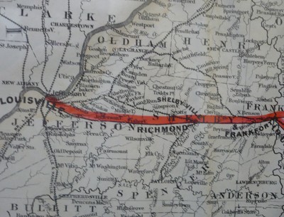
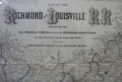
Louisville and Richmond Railroad Map Dated 1882 Description: Lithograph Map of the Richmond and Louisville Railroads, by G.W. & C.B. Colton of New York, Dated 1882. This map connects the Railroads of Virginia with the Railroads of Kentucky on the Shortest route East and West from the Mississippi Valley to the Atlantic Ocean. With neat lines, plus full borders. This lithograph retains the original highlight colors to show routes in blue and red. Some separations are evident at the joins of folds, as expected, and folds into its original 10 x 5 paper case. This map was issued to illustrate the various railroad lines in Virginia, West Virginia and Kentucky, as well as connecting lines in neighboring states. Its copious detail of these railroad systems would have provided excellent information for the many travelers and businessmen interested in the transportation network in the area at the end of the nineteenth century. Detail is given of rivers and towns as far west as Louisville and Cincinnati on the Ohio River, south to Knoxville in Tennessee and to Greensboro, Durham and Albemarle Sound in North Carolina. In the east all of Chesapeake Bay, the states of Maryland and Delaware and to the upper right corner the city of Philadelphia are depicted. Topography is shown using the hachuring method. Condition: is great overall, now framed and conserved. see photos. Dimensions: Height- 32.75 Width- 56 Price: $2,800.00 Item ID: 23095 (use this number when calling our gallery) Print this item | ||||
| Home About Us Search |